The use of data provided by various satellite systems has been gaining popularity since the 1970s – when the first remote sensing Earth imaging satellite Landsat 1 was launched. Recently, we can see an increasing interest in satellite imagery due to the Ukraine war crisis. There is a growing awareness, among both the public and the decision-making bodies, of how useful this kind of data can be in times of crisis. Hopefully, this will also contribute to more and more people becoming aware and taking advantage of the full range of applications that satellite imagery offers – especially environmental ones. To make this happen, let’s once again look a little more closely at the basic characteristics of this type of data.
Basic parameters of geo-imaging satellite systems
The basic parameters of Earth Observation data are:
- spatial resolution,
- temporal resolution,
- spectral resolution,
- radiometric resolution.
This article will address the issue of spectral and radiometric resolutions. We wrote about the other parameters – spatial and temporal resolution – in the previous part of the article [Link].
Spectral resolution
As the definition implies, with regard to satellite images, spectral resolution ‘defines the number of spectral channels (bands) that are collected by the satellite and their width. The higher the spectral resolution, the more information we can obtain about the imaged surface.’ [1].
But let’s start from the beginning and get back to basics. Visible light, that is, one that is perceptible by the human eye, constitutes only a small part of the total spectrum of electromagnetic radiation. If we take a look at the spectrum diagram, we can see that further ranges of radiation like infrared radiation, microwaves, or radio waves are frequency ranges that are imperceptible to us. Yet, these waves do exist in the environment in which we live, and we are able to create systems that use their properties. Hence, remote sensing systems record the portion of radiation reflected from the Earth’s surface and the objects present on it in several separate wavelength ranges (so-called spectral bands or channels) – including those outside the visible range. A spectral band (channel) represents a selected part of the electromagnetic radiation spectrum (Fig.1).
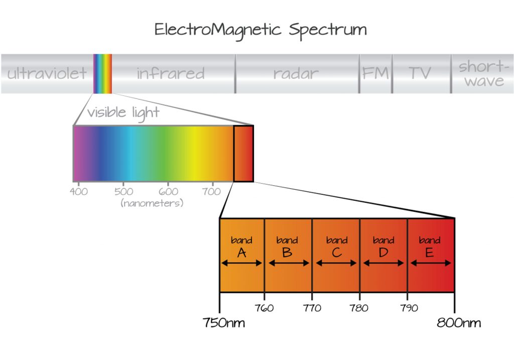
Fig. 1. Wave range of electromagnetic radiation spectrum/ Electomagnetic wave spectrum (Source https://www.earthdatascience.org/courses/earth-analytics/multispectral-remote-sensing-data/introduction-multispectral-imagery-r/) (Accessed: 01.01.2022)
The information recorded by the satellite system is stored as rasters. One pixel in a given raster can take only one value. Therefore, a satellite image (satellite scene) is actually a collection of several rasters (images) (Fig.2). The values of recorded spectral reflectance for a pixel in a given raster refer to the degree of reflectance of that surface in a given range of electromagnetic radiation. That is, when collecting data, the satellite system creates one raster for each spectral range recorded. For systems that record data in the visible range (in the three ranges of blue, green, red), the satellite scene will consist of 3 channels (rasters).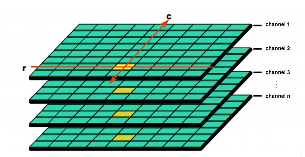
Fig. 2. Structure of the satellite scene (Source:[2])
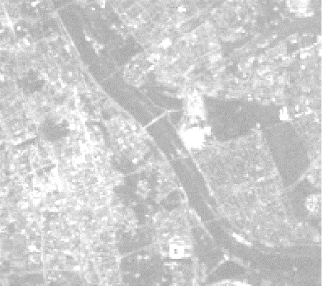
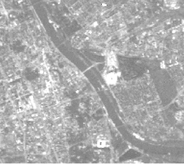
The world’s first available satellite imagery acquired by the Landsat 1 satellite (which was initially named ERTS-1 – Earth Resources Technology Satellite, only later given the name recognized today) provided images in 4 spectral channels: 3 visible channels (red, blue, green) and an infrared channel [3]. With the development of satellites and technological advances, the number of spectral channels in the various satellites available was often increased. Nowadays, there are sensors that provide data acquired in up to several hundred spectral channels, such as Hyperion. However, the most common channels remain to be the visible channels, which are often enhanced with an infrared channel and several additional channels (Fig.3).
 |
 |
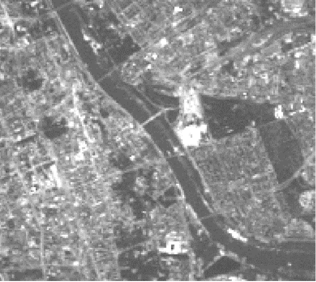 |
| Channel 1 – blue – 0.45-0.52 µm | Channel 2 – green – 0.52-0.60 µm | Channel 3 – red – 0.63-0.69 µm |
 |
 |
 |
| Channel 4 – NIR – 0.76-0.90 µm | Channel 5 – SWIB – 1.55-1.75 µm | Channel 6 – Thermal- 10.40-12.50 µm |
 |
||
| Channel 7 – SWIR – 2.08-2.35 µm |
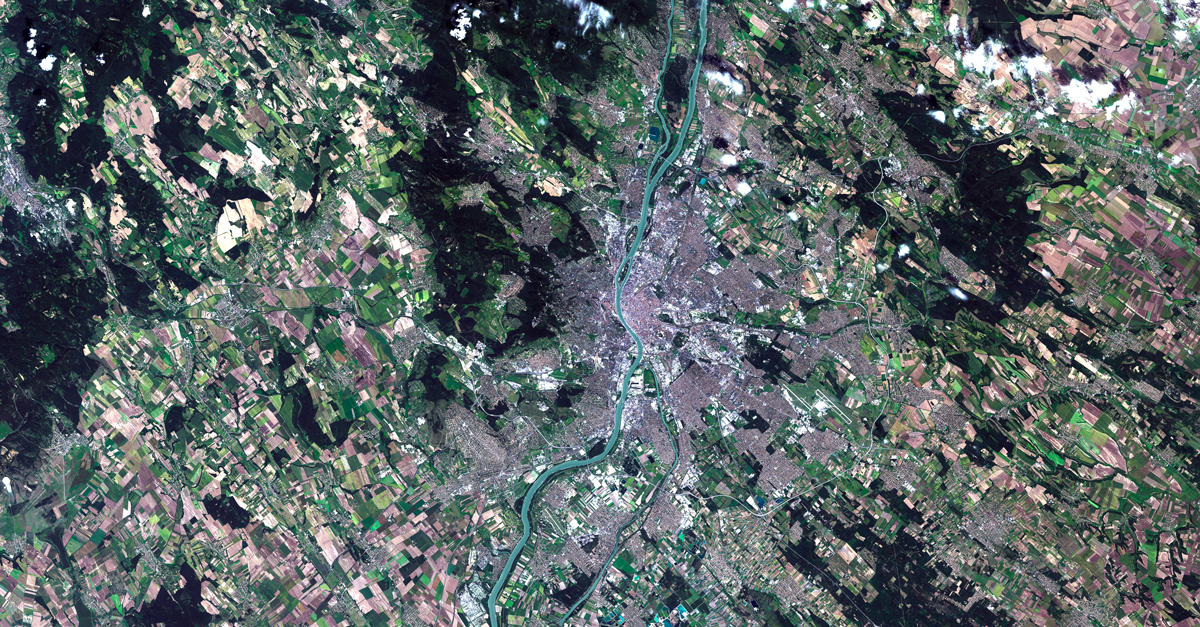
Fig. 3. Comparison of spectral channels of Landsat 5 imaging (Warsaw, 27.08.2011)
When designing satellites and their sensors, we must keep in mind that different objects on Earth have different properties of reflecting and absorbing electromagnetic radiation in given wavelength ranges. Satellite remote sensing often takes advantage of these properties and, by knowing the reflectivity of different objects, allows them to be distinguished from each other in satellite imagery. Satellite systems that record data in multiple spectral channels allow us to better distinguish objects from each other and to better understand the properties of these objects, such as whether vegetation is healthy or suffers from water stress. Hence, we can continuously observe a trend in increasing the spectral resolution of the satellite systems developed, as this allows us to see more features of the imaged surface.
When selecting the spectral ranges in which a given satellite system is to image, we must also keep in mind the existence of the so-called atmospheric windows. These are wavelengths’ ranges that are transmitted (not absorbed) by the Earth’s atmosphere. Looking at the entire spectrum of electromagnetic radiation, we can see that we often have gaps in the successive ranges of wavelengths that a given spectral channel covers. This is precisely because, for certain wavelength ranges, all of the electromagnetic radiation is absorbed by the Earth’s atmosphere.
With the increase in the number of spectral channels in which satellite systems image, a corresponding division has been introduced. Currently, based on spectral resolution, images are divided into:
- panchromatic images (one spectral channel in the visible range)
- multispectral images (several channels)
- hyperspectral images (up to several hundred channels)
- ultraspectral images (thousands of channels)
Panchromatic images are acquired over a broad band covering the entire visible range[4]. Multispectral images cover the range of several spectral channels and are currently the most common images from satellite remote sensing systems. Most often, multispectral images are accompanied by a panchromatic channel. Advanced hyperspectral and ultraspectral sensors, detect hundreds and thousands of very narrow spectral bands across the visible, near-infrared and mid-infrared portions of the electromagnetic spectrum. Their very high spectral resolution makes it easy to accurately distinguish between different targets based on their spectral response in each of the narrow bands. Such satellite systems are still groundbreaking in a way, but it is possible that they will revolutionize the satellite imagery market in the coming years. Certainly, the number of hyperspectral systems will continue to grow, as many well-known satellite imagery providers are building such systems.
Radiometric resolution
It is understood as the number of distinguishable radiation levels (or bits) into which the recorded energy is divided[1]. It provides us with information on how sensitive a given satellite sensor is to the intensity of reflected electromagnetic radiation.
To better visualize the importance of radiometric resolution of satellite imagery, we can imagine a satellite system acquiring data with very good spatial resolution and a radiometric resolution of 1 bit. What does it mean in practice? This type of sensor can inform us, whether any radiation value from the object has returned for each pixel. However, it will not provide us with information on what the value of this radiation was. For objects that reflected radiation and some of it returned to the satellite it will take the value 1, and for those for which no radiation was registered by the sensor, it will take the value 0. We can easily realize that this type of information in the case of satellite imagery is insufficient. In addition, very high spatial resolution seems useless when combined with such a low radiometric resolution. As the value of radiometric resolution increases, the sensor’s sensitivity to the value of reflected radiation increases. Therefore, it is important to ensure a minimum value of radiometric resolution in any satellite system. Just by comparing ordinary digital photos (Fig. 4), we can realize the role of radiometric resolution.
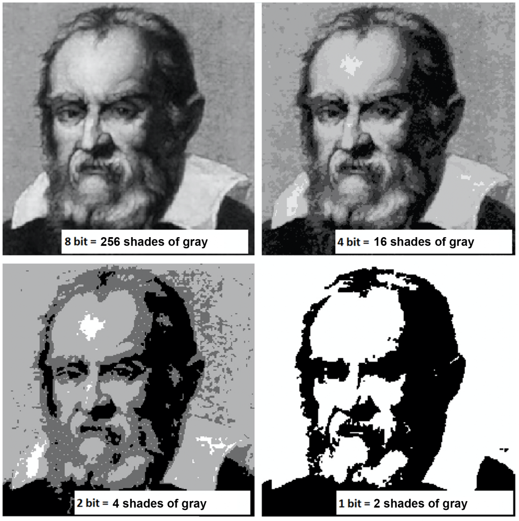
Fig. 4. Example of a digital photo with different bit depths (Source: https://vedas.sac.gov.in/vedas/downloads/ertd/DLD/L_1_Basics_of_Remote_Sensing_Hiren_Bhatt.pdf)
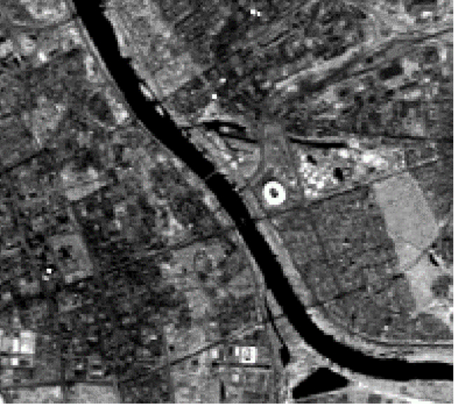
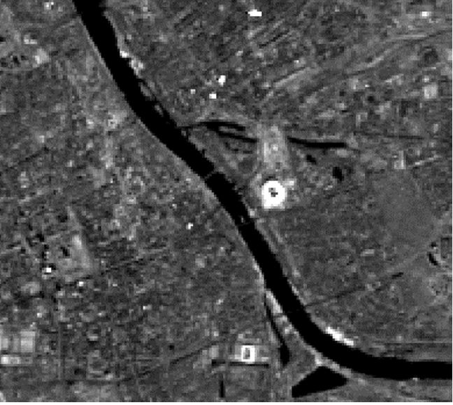
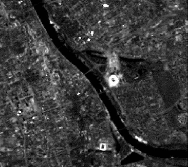
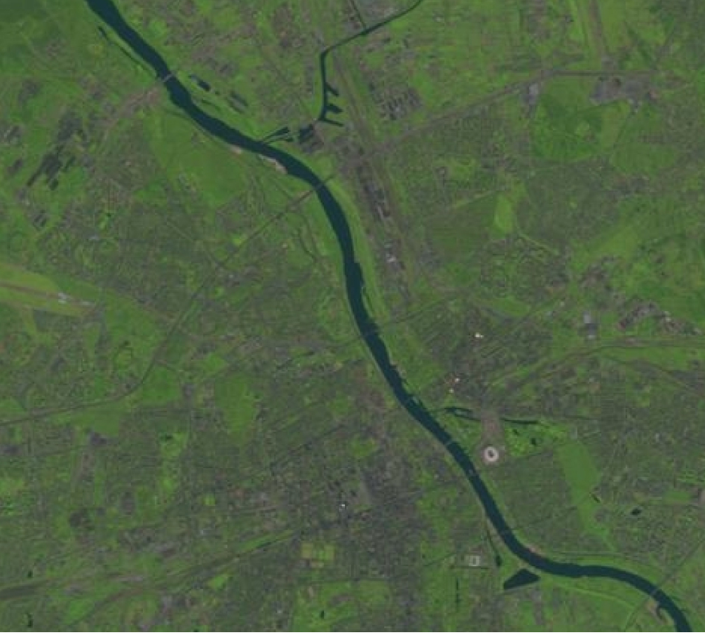
Currently, satellite imagery is usually recorded as 8-bit images (256 gray tones), such as Landsat TM images. Very high-resolution images are often captured in 11-bit (they have 2048 gray tones) or 12- or 16-bit (Fig. 5). In comparison, color images can range from 8 to 24 bits (16.7 million colors). For 8-bit images, we have much more possibilities than for the above-mentioned example. In this case, a single pixel of satellite imaging can take on a value in the range of 0 to 255, which gives us a much greater ability to distinguish objects on the Earth’s surface. A comparison of examples of satellite imagery provided as 8-bit and 16-bit images is presented below using Landsat imagery as an example (Figure 6).
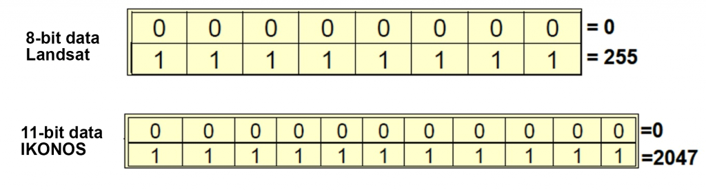
Fig. 5. Data recording on 8 and 11 bits (Source:[2])
 |
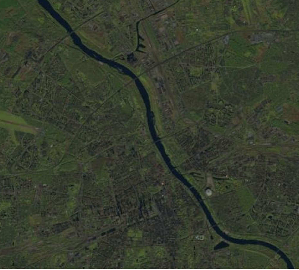 |
| Landsat 5 – 8 bit (Warszawa, 27.08.2011) | Landsat 8 – 16 bit (Warszawa, 01.11.2021) |
Fig. 6. Comparison of Landsat satellite imagery with different radiometric resolution.
The higher the radiometric resolution, the greater the ability of the sensor to detect differences in the amount of reflected electromagnetic radiation. Again, a greater sensitivity to the difference in reflected radiation gives us the ability to distinguish healthy, green, healthy vegetation from dry vegetation. This is all due to the fact that we know that in the red radiation range, dry vegetation will have a much higher reflected radiation value than the healthy, green vegetation [5].
In summary, we can see that satellite imagery can be characterized not only by different spatial and temporal resolution (as described in the previous part of the article), but also by spectral and radiometric resolution. All of these characteristics determine the usefulness of satellite data acquired by a given sensor, so when selecting data for dedicated usages, we should take all of these characteristics into account. They are always closely related. In recent years, these parameters are constantly improving, and this is directly related to the acquisition of very large volumes of satellite data. Nowadays, another challenge we face is how to deal with efficiently transferring or storing ever-increasing amounts of data.
Sources:
[1] Wężyk Piotr, Cisło-Lesicka Urszula (2021) „Wprowadzenie do danych satelitarnych”, Dane satelitarne dla administracji publicznej
[2] Osińska-Skotak Katarzyna (2013) „Przetwarzanie i interpretacja zdjęć satelitarnych”, W ramach zadania 27 Programu Rozwojowego Politechniki Warszawskiej
[3] Koncency Gottfired (2003) „Geoinformation: Remote Sensing, photogrammetry and geographic information systems” CRC-Press
[4] Bajorek-Zydroń K., Chormański J., Cisło-Lesicka U. i in.(2020) „Dane satelitarne dla administracji publicznej”, Sat4ENVI – System operacyjnego gromadzenia, udostępniania i promocji cyfrowej informacji satelitarnej o środowisku
[5] Donald P. Albert (2000) „Spatial Analysis, GIS and Remote Sensing”, Applications in the Health Sciences